
Groundwater irrigation from the High Plains Aquifer—the largest freshwater aquifer in North America—has helped transform the overlying portions of Tenth District states Colorado, Kansas, Nebraska, New Mexico, Oklahoma, and Wyoming into one of the most productive agricultural regions in the world (Lovelace and others 2020; McGuire and Strauch 2024)._ Irrigation is a critical risk management tool during droughts, allowing farm operators to optimize growth, enhance nutrient uptake, and protect against heat stress in hot and dry conditions. Accordingly, irrigated farmland commands higher values relative to dryland.
This premium, or difference between irrigated and non-irrigated farmland values, has increased as drought has increased the value of reliable irrigation in agricultural production. Over the last two decades, multi-year dry periods, record-high temperatures, and declining winter snowpack have increased the incidence and severity of drought in the western United States (Zhuang and others 2024). Chart 1 shows that during this period, the premium for irrigated farmland has risen across the Tenth District. Notably, the premium has increased faster during droughts, illustrating the value of secure access to water in times of water scarcity.
Chart 1: Premium for irrigated farmland in the Tenth District rises faster during droughts
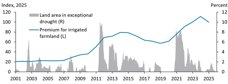
Notes: The premium for irrigated farmland is calculated as the difference between average surveyed land values (per acre) of irrigated and non-irrigated farmland across the Tenth District, indexed to 2025 to account for inflation. Exceptional drought refers to the highest intensity level on the U.S. Drought Monitor, indicating a one-in-100-year event.
Sources: Federal Reserve Surveys of Agricultural Credit Conditions and the National Integrated Drought Information System’s U.S. Drought Monitor.
Although droughts have driven up irrigated land value premiums thus far, the severe depletion of groundwater could threaten these premiums in the long term. Chart 2 shows how irrigated premiums have evolved since 2010 in Kansas, Nebraska, and Oklahoma—three states with varying reserves of available groundwater. The irrigated land premium is higher for Nebraska (which has ample reserves of groundwater) than for Kansas (which has large but declining reserves of groundwater) and the irrigated land premium for Kansas is higher than for Oklahoma (which has low remaining reserves of groundwater). The positive relationship between irrigated land value premiums and groundwater reserves is indicative of operators’ confidence in the long-run availability of water for agriculture. Severe groundwater depletion can hurt farm finances by reducing well yields and increasing pumping costs (Perez-Quesada, Hendricks, and Steward 2024). Elevated future risk from reduced yields from insufficient irrigation or the need to convert production to dryland crops ultimately manifests in lower irrigated land premiums, as in Oklahoma.
Chart 2: Irrigated land premiums vary across Nebraska, Oklahoma, and Kansas
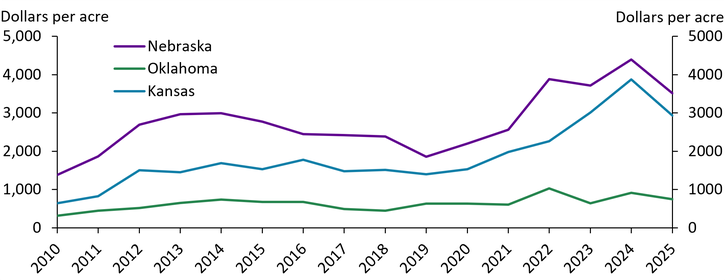
Notes: The premium for irrigated farmland is calculated as the difference between the average land values per acre for irrigated and non-irrigated farmland across Kansas, Nebraska and Oklahoma, adjusted for inflation using the Consumer Price Index with 2010 as the base year.
Sources: Federal Reserve Surveys of Agricultural Credit Conditions and U.S. Bureau of Labor Statistics.
The resilience of irrigated land premiums to groundwater depletion across the Tenth District varies with geographic differences in climate, soil, water use, and aquifer recharge. Map 1 illustrates the degree of aquifer depletion that occurred between 1950—before the aquifer was developed for irrigation—and 2019. In Nebraska, the average level of groundwater declined by less than a foot, while in Kansas, the average level declined by 27.3 feet (McGuire and Strauch 2024). Nebraska has permeable, coarse-textured soils along with greater precipitation and a shallower water table, enabling higher rates of recharge and less intensive water use (Scanlon and others 2012). In southwestern Kansas, however, patterns of low precipitation, high evaporation, and less porous soil prevent water from percolating to the water table and encourage more intensive water use._ The interplay between water use and recharge creates different degrees of risk from depletion across the High Plains Aquifer.
Map 1: Groundwater depletion in the High Plains Aquifer from 1950 to 2019 varies across states
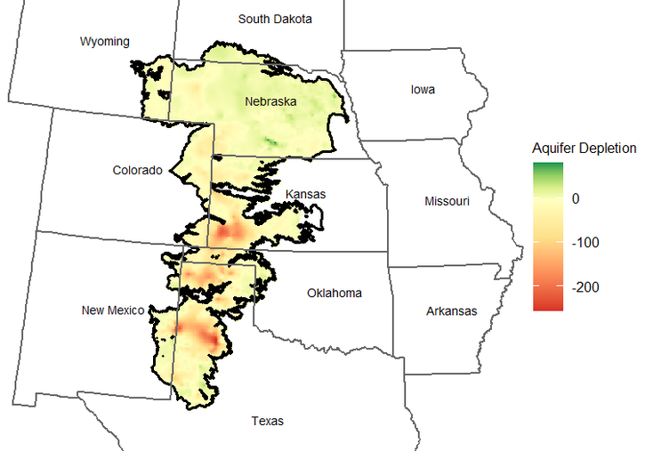
Note: Aquifer depletion refers to the water-level change in feet from 1950 (pre-development of the aquifer) to 2019.
Source: U.S. Geological Survey Groundwater and Streamflow Information Program.
While groundwater depletion threatens irrigated land value premiums, effective management and innovation in agricultural production technologies appear to have mitigated some of these risks more recently. In the 1970s, widespread depletion across the aquifer after decades of unrestricted access led to the establishment of decentralized state-level groundwater management regimes (McGuire and others 2003)._ Permit requirements, well moratoriums, and water allocations established rights to pump and coordinated water use across producers, limiting groundwater extraction and incentivizing more efficient water use (Perez-Quesada, Hendricks, and Steward 2024). Panel A of Chart 3 shows that irrigated acreage (blue line) has remained broadly stable over the Tenth District over the last 20 years, but the volume of water applied (purple line) to these acres has declined. Panel B of Chart 3 shows that, over the same period, corn producers have increased yields despite less water use, thanks to innovation in irrigation technology along with yield improvements from drought-resistant seed technology._
Chart 3: Although total water use has declined, corn yields have increased
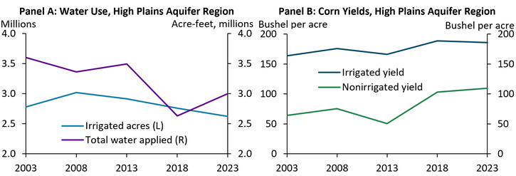
Notes: Chart shows average irrigated acres, total water applied, and both irrigated and non-irrigated corn yields for Colorado, Kansas, Nebraska, New Mexico, Oklahoma, and Wyoming. Missouri was not included given lack of overlap with the High Plains Aquifer.
Sources: U.S. Department of Agriculture’s Census of Irrigation.
While irrigated land premiums across the Tenth District have increased on average over the last two decades with increased incidence of drought, the long-term resilience of irrigated land values depends on local rates of aquifer replenishment, effective groundwater management, and continued innovation in agricultural production. Risks to irrigated land value premiums from prolonged or severe drought are greatest in the Tenth District where depletion is already advanced, stored water levels are low, and recharge is limited, as in New Mexico and Oklahoma. Continued innovation in irrigation technology and seed technology can offset groundwater pressure and bolster irrigated land values in the long-term via more efficient water use.
Endnotes
-
1 The Tenth Federal Reserve District includes Colorado, Kansas, Nebraska, Oklahoma, Wyoming, and parts of Missouri and New Mexico.
-
2 See, for example, the difference between the USGS map depicting depletions levels from pre-development to 2015 (McGuire 2017), following years of prolonged and severe drought, and the same map depicting depletion from pre-development to 2019, after more typical precipitation patterns across the region (McGuire and Strauch 2024).
-
3 Groundwater management is overseen by the eight states overlying the aquifer and is often further decentralized into different districts within each state. For a summary of the legal doctrines, conservation regimes, and policy tools employed across these districts, see McGuire and others (2003).
-
4 Drought-resistant seed technology has supported growth in non-irrigated corn yields at a faster rate than irrigated corn. Concurrently, non-irrigated land values have grown quickly over the same period, putting downward pressure on the rate of growth in irrigated land premiums.
Article Citation
Cooray, Ayesha. 2026. “How Will Drought and Groundwater Depletion Affect Irrigated Farmland Values in the Tenth District?” Federal Reserve Bank of Kansas City, Economic Bulletin, June 24.
References
McGuire, Virginia L., M. R. Johnson, R. L. Schieffer, J. S. Stanton, S. K. Sebree, and Ingrid M. Verstraeten. 2003. External LinkWater in Storage and Approaches to Ground-Water Management, High Plains Aquifer, 2000. U.S. Geological Survey Circular, vol. 1243.
McGuire, Virginia L., and Kellan R. Strauch. 2024. External LinkWater-Level and Recoverable Water in Storage Changes, High Plains Aquifer, Predevelopment to 2019 and 2017 to 2019. U.S. Geological Survey Scientific Investigations Report no. 2023–5143.
McGuire, Virginia L. 2017. External LinkWater-Level and Recoverable Water in Storage Changes, High Plains Aquifer, Predevelopment to 2015 and 2013–15. U.S. Geological Survey Scientific Investigations Report no. 2017–5040.
Perez-Quesada, Gabriela, Nathan P. Hendricks, and David R. Steward. 2024. “External LinkEconomic Cost of Groundwater Depletion in the High Plains Aquifer.” Journal of the Association of Environmental and Resource Economists, vol. 11, no. 2, pp. 253–285.
Scanlon, Bridget R., Claudia C. Faunt, Laurent Longuevergne, Robert C. Reedy, William M. Alley, Virginia L. McGuire, and Peter B. McMahon. 2012. “External LinkGroundwater Depletion and Sustainability of Irrigation in the U.S. High Plains and Central Valley.” Proceedings of the National Academy of Sciences, vol. 109, no. 24, pp. 9320–9325.
Zhuang, Yizhou, Rong Fu, Joel Lisonbee, Amanda M. Sheffield, Britt A. Parker, and Genoveva Deheza. 2024. “External LinkAnthropogenic Warming Has Ushered in an Era of Temperature-Dominated Droughts in the Western United States.” Science Advances, vol. 10, no. 45.
Ayesha Cooray is an economist at the Federal Reserve Bank of Kansas City. The views expressed are those of the author and do not necessarily reflect the positions of the Federal Reserve Bank of Kansas City or the Federal Reserve System.
Author